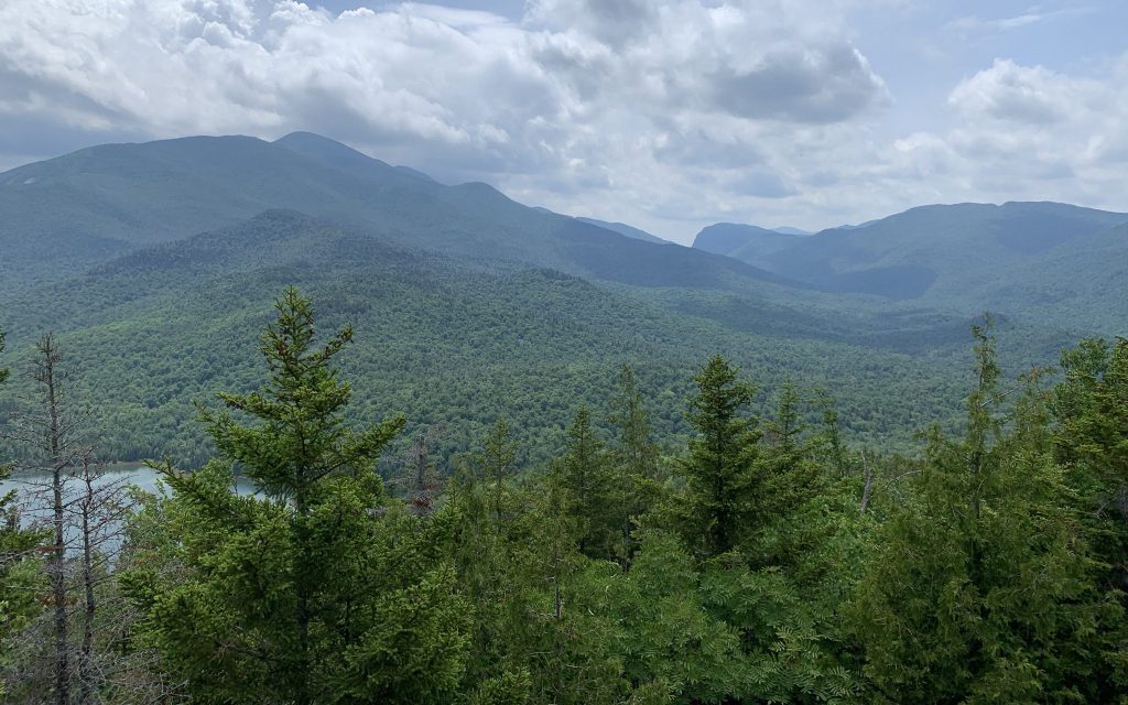
Hiking up and down mountains requires hikers to be in very good physical shape. Whether, the hike involves traversing a few hundred feet to an overlook at your local state park or hiking up some of the highest mountains in the world; the basics are still the same.
Factors to Consider
Its important to note that the following conditions will be more severe at higher elevations. If you’re hiking at an elevation of 1,000ft (304m) these conditions will be less impactful than if you are hiking at an elevation of 15,000ft (4,572m). However, it’s important to know the risks no matter the elevation, because with any change in elevation comes with a possible sudden change in conditions.
Hiking in changing elevation comes with its own set of challenges. Rather than the standard risks of hiking a flat trail (getting lost, wildlife and weather); hikers who travers trails across different elevations have the added risks of rapidly changing weather, rapidly decreasing temperatures, thinning air and must be in good physical fitness.
Rapidly Changing Weather
Hikers who hike in changing elevations could experience drastic weather changes. A hike could start in 40o or 50o Fahrenheit (4o C-10o C) weather at the base of a mountain, but by the time a hiker reaches the top, the temperature could be 20o Fahrenheit (-6o C) and snowing. Hikers need to be prepared for a more drastic change in weather over a shorter time. This could involve carrying extra clothing, to being prepared to quickly get off the mountain if conditions become too severe.
Decreasing Temperature
As elevation increases, temperatures will decrease (and sometimes wind will increase too). That’s because air is thinner at higher elevations and we are further away from the ground, where much of Earth’s heat is stored. A good rule to follow is for every 1,000ft (304m) increase in elevation; the temperature will drop 3.5-5o Fahrenheit (for those using the metric system, for every kilometer increased in elevation, the temperature will drop ~6o C) . Hikers who hike at elevation have to plan for decreasing temperatures along the trail.
Thinner Air
With increasing elevation comes decreasing air and oxygen. The body requires oxygen to properly function, and where it doesn’t get enough there can be serious health effects. Acute Mountain Sickness (AMS) is a common, but a serious condition that directly effects the brain. Symptoms include impaired judgement, dizziness/loss pf balance, and headaches. Symptoms typically appear between 6 and 24 hours after reaching an elevation over 10,000ft (3,040m). If left untreated, the condition could become fatal. Some mountain climbers will carry bottled oxygen to help prevent AMS when scaling the largest mountains in the world (like Mount McKinley and Mount Everest).
Physical Fitness
Hikers traversing elevation need to be prepared for a wider array of situations. As a result they are likely carrying more gear. The increased weight of their hiking bag and the added effort of hiking a slope that could be steeper than a flight of stairs means their heart has to work harder. The added effort needed to hike in elevation means hikers have to have more stamina and and be in overall better physical shape than just a causal hiker walking around their local park.
Elevation and Altitude
If we want to better prepare for hikes at elevation, we need to talk about its relation to altitude. Simply put, elevation refers too how high some geographical feature is from sea level; for example, the height of a mountain. Sea level is often used because it serves as a topographical reference point across Earth for measuring depth and height. The closest you can get to Earth’s surface without going below the crust. It serves as a universal reference point for all height and measure based sciences.
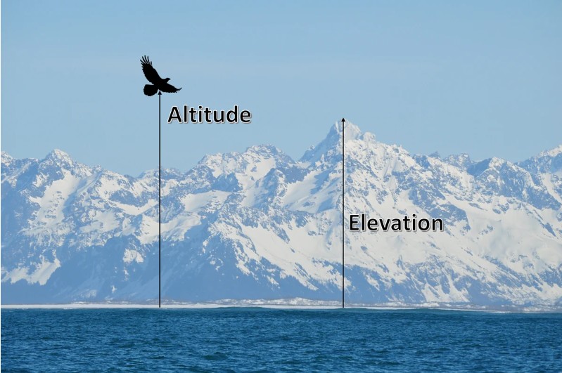
This is slightly different than altitude. Altitude is measuring the height of a fixed object above the ground or some other reference point. For example, a hiker on a mountain can be at an altitude of 5,000ft (1,524m) above sea level; however, if the mountain is 2,000ft (609m) above sea level, then the hiker is at an elevation of 3,000ft (914m).
Measuring Steepness-Elevation Gain
Elevation gain is a term often seen on digital trail maps and various fitness trackers. Some hikes can begin and end at the same elevation; so listing the starting and ending elevation may not give the hiker a good representation of the elevation changes. Some maps could list the highest and lowest elevation along the hike, but again it may not be representative of the trail. This is where the term “elevation gain” comes in.
Elevation gain is the total vertical distance climbed during a hike. For example, if you started at sea level and climbed 500ft, then descended 200ft, and then climbed another 300ft. Your elevation gain would be 800ft (500ft + 300ft=800ft), even though your elevation on the trail only went up by 100ft.
Calculating Elevation Gain
Calculating elevation gain per mile is easy if your trail is a mile, but how would you know your elevation gain per mile on a trail that’s 3 or 4 miles (4.8-6.4 km) in length? It’s simple, if a 4 mile (6.4 km) trail has an elevation gain of 1,000ft (304 meters), the elevation gain per mile would be 250ft (76m) per mile. That is calculated by dividing the elevation gain by the total distance; in this case 1,000 divided by 4 which equals 250.
For an out and back trail (that’s a trail where you hike to some point and return along the same route) the conversion would include one additional step. Since hiking an out and back trail involves going uphill in one direction and downhill in the return direction, first the total mileage of the trail must be divided by two. For a 6 mile out and back trail, the mileage used for the conversion would be 3, a 4 mile out and back trail would be 2 miles for the conversion. The second step where the elevation gain is divided by the mileage is still the same.
Elevation Grade
The last piece of knowledge to know when reviewing elevation hikes is grade. We often see this sign along the road when driving in hilly areas and most of us probably ignore it. However, to a hiker, grade can help determine how to prepare and what to expect along the trail.
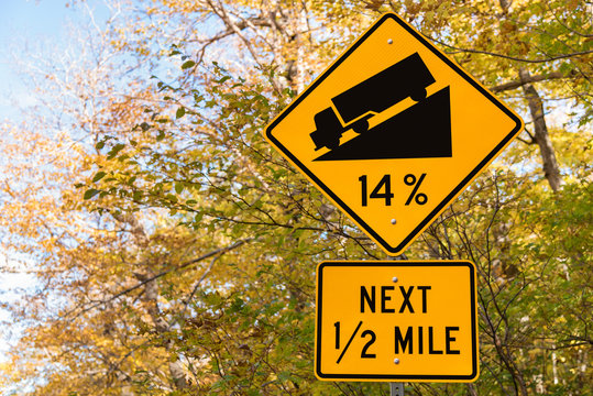
Grade is often expressed as a percentage and can vary widely along a trail. Think of grade as degrees of inclination (if positive) and declination (if negative). Think back to math class and discussing angles and straight lines. 0 degrees means there is no inclination and the line is flat. 90 degrees means the line is vertical. That is essentially elevation grade only expressed as a percent. The higher the number the steeper the incline.
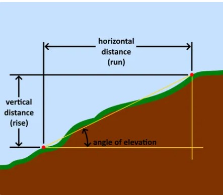
A 50% elevation grade will be steeper than a 20%, which will be steeper than 10%. If these numbers are negative, then it means the terrain is going downhill. This percentage will change with distance. If the 30% grade is over the course of a mile then the incline will be much shallower than if it was over 200 or 300ft.
While elevation grade and elevation gain will not fully prepare us for a hike in the mountains, they are tools to help hikers understand the trail they are planning so they can be properly equipped. Of course, experience, fitness and weather all play a role in how versed a hiker is at handling the changes that come with elevation changes on a trail. It’s always important to know your limits when hiking and study the train ahead of time so you can prepare yourself for whatever lies ahead.
References
- https://psmsl.org/train_and_info/faqs/
- https://www.geographyrealm.com/what-is-the-difference-between-elevation-and-altitude/
- https://www.mooremisadventures.com/blog/hiking-101-basics
- https://www.omnicalculator.com/construction/elevation-grade
- https://science.howstuffworks.com/nature/climate-weather/atmospheric/question186.htm
- https://lonestarneurology.net/others/the-neurological-risks-of-high-altitude-hiking-what-every-adventurer-should-know/
- https://scied.ucar.edu/learning-zone/atmosphere/change-atmosphere-altitude
