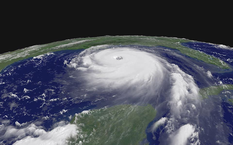
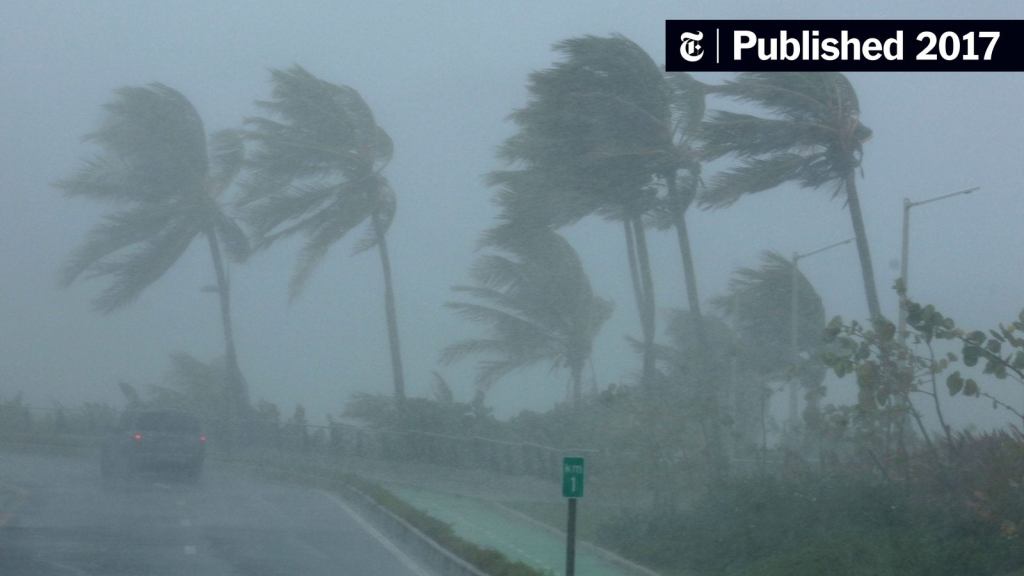
If you’ve been following the news lately, then you’ve probably heard of Hurricane Helene and Hurricane Milton. Hurricane Helene made landfall on September 26th, 2024 in the gulf coast town of Big Bend in northwestern Florida. The category 4 hurricane then traveled across central Georgia, with the eye of the storm passing about 40 miles east of Atlanta. As Helene weakened to a category 2 and eventually a tropical depression on September 29th, the storm would still cause major damage to the residents in the Appalachia Mountain region between western North Carolina and Eastern Tennessee.
Hurricane Milton made landfall on the western coast of Florida near Sarasota on October 10th, 2024 as a category 3 storm. Milton would travel east across Florida, leaving destroyed homes, flooding and tornados in its wake. On October 11th, Milton would leave Florida behind and continue east out into the Atlantic Ocean. At the time of this article, the death toll and financial costs of these two storms has not been determined. However, the death toll is expected to be in the hundreds while the financial recovery is expected to cost billions of dollars. The severity of these storms raises some serious questions, such as are these storms getting stronger and is their path changing?
HOW HURRICANES FORM
In order to understand hurricanes, we first need to understand how they form. To do that we have to look at our atmosphere. Our atmosphere contains areas of high air pressure and low air pressure. High pressure will push air away, while low pressure will bring air in.
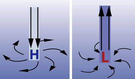
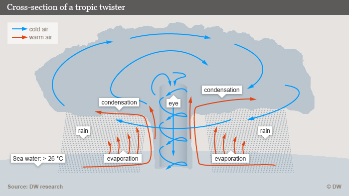
Hurricanes start their formation when an area of low pressure settles over warm tropical water. Fast moving humid air then rushes in to areas of low pressure. This warm humid air quickly rises, cools and condenses to form thunderstorm clouds. You can read about the cloud formation process here and more about high and low pressure differences here!
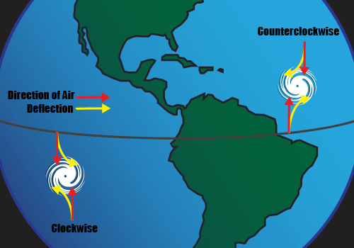
As the thunderstorms build, there is very little wind to disrupt their formation. The Coriolis Effect-an effect where winds begin to circulate due to the rotation of the Earth-begin to push the storms into a spiral movement. In the northern hemisphere, the rotation is counterclockwise, while in the southern hemisphere is clockwise. This rotation, coupled with very little wind disturbance, means a tropical disturbance is formed. Once the winds reach 74mph, the storm is now a category 1 hurricane.
So to recap how hurricanes form:
- A low pressure area settles over warm tropical water.
- Humid air rushing to fill the low pressure area.
- Hot and humid air rises, condenses and falls, creating thunderstorms.
- The Coriolis Effect begins pushing the air into a spiral movement.
THE CORIOLIS EFFECT AND HURRICANE PATHS
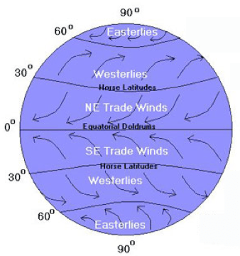
To better understand the Coriolis Effect, we have to look at Earth’s rotation. Air at the poles will travel slower than air along the equator. That’s because the air along the equator has a greater distance to travel in the same amount of time (24 hours). As air circulates and faster air along the equator travels north, air will continue to travel in the direction of the faster air. An example is trying to throw a ball between two passing vehicles at different speeds.
If you throw the ball when you are exactly opposite of the slower vehicle, you will miss every time because the ball is traveling at the speed of the faster car, not the slower car. The same is true for air currents, NE trade winds travel east to west along the equator (because of the faster moving air) while winds further north (called westerlies) travel west because they are moving slower and push the trade winds. It is this direction of travel that causes hurricanes to rotate and travel north and east in the northern hemisphere.
Determining the path of hurricanes can be nearly impossible. These storms thrive on warm water and low pressure systems. As a hurricane moves east, the counterclockwise rotation pushes the storm north where it loses energy. The westerly wind then pushes the storm east up the coast or out to the Ocean.
Of course there are exceptions to this direction of travel and there are a lot more factors when trying to predict the path of a hurricane. However, determining strength is much easier. Hurricanes are classified on a 1-5 scale with 5 being the most dangerous and highest sustained winds. Category 5 sustained winds can exceed 150mph and can destroy some of the most well built structures.
HURRICANES STRENGTH
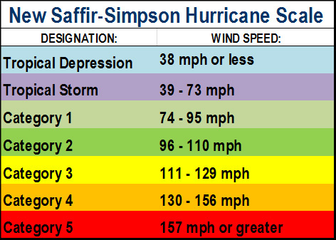
The Saffir-Simpson Hurricane Wind Scale classifies hurricanes based on their sustained winds and gives them a ranking of between 1 and 5, with 5 being the worst. A category 5 hurricane can have sustained winds of over 157mph, and that does not take into account other threats such as tidal surges or rain.
At its peak, Hurricane Milton had a sustained wind of nearly 180mph, making it the strongest sustained winds since Hurricane Irma in 2017. Hurricane Helene had a maximum wind of 140mph, but wind itself does not define the strength of a storm. There are many other factors that go into determining a storms strength.
ARE HURRICANES GETTING STRONGER?
There are many scientists claiming that hurricanes Milton and Helene got their boost from climate change. While it is impossible to know for sure if climate change made these storms stronger, we can illustrate the perfect storm of circumstances that needed to happen in order to make these storms deadly.
According to MSNBC, Hurricane Helene was the strongest storm ever to hit the Big Bend region of Florida and the 3rd to hit in the las 13 months. Prior to Hurricane Idalia in August 2023 (a category 4 hurricane), this area of Florida hadn’t seen a hurricane in nearly a century. This area of Florida is normally protected by the Apalachee Bay in the panhandle and doesn’t see a lot of storms. In North Carolina, the last category 4 hurricane to was Hurricane Hazel in 1954. Residents in both Florida and North Carolina simply weren’t prepared for a major hurricane. Their homes weren’t built to withstand a storm this powerful. Additionally, the remoteness of the region and mountainous terrain has made the rescue operation and supply distribution even more challenging.
If you’re wondering about the two quick storms back to back, well that may be more common than you think. Hurricane Katrina (August 2005) and Rita (September 2005) were both category 5 storms that hit the U.S just weeks apart. In 2017, Hurricane Irma (August/September 2017) and Hurricane Maria (September 2017) hit the Caribbean Islands and U.S territories just 10 days apart. That same year Hurricane Harvey would hit Texas on August 25th. Hurricanes Irma and Maria were category 5 storms while Hurricane Harvey was a category 4.
CONCLUSION
The climate change discussion is a complicated one, and a post for a different time (maybe). It’s impossible to definitively know if/how climate change affected these storms and hurricanes in general. One thing is for sure though, Earth goes through cycles of weather patterns. Everything from our orbital rotations, to solar flares and auroras to volcanic activity affect what happens here on Earth. Generally these cycles come in waves of intense activity every 7 to 10 years.
Hurricanes and other major weather events will continue to happen. So what we can learn from these storms is to always be prepared, have an escape route planned as well as some emergency food, generators and other critical life supplies, so the next time a major storm comes, you’ll be ready.
REFERENCES
- https://www.cnn.com/2024/10/01/weather/hurricane-helene-path-of-destruction-climate-dg/index.html
- https://oceanservice.noaa.gov/facts/how-hurricanes-form.html
- https://scied.ucar.edu/learning-zone/storms/how-hurricanes-form
- https://geowork.blogspot.com/2017/09/how-are-hurricanes-formed.html
- https://www.nhc.noaa.gov/aboutsshws.php?
- https://www.climate.gov/news-features/event-tracker/hurricane-milton-rapidly-intensifies-category-5-hurricane-becoming
- https://www.britannica.com/event/Hurricane-Helene
- https://earthobservatory.nasa.gov/images/15550/hurricane-rita
- https://www.msnbc.com/jose-diaz-balart/watch/helene-slams-florida-as-category-4-hurricane-strongest-to-ever-hit-big-bend-region-220302917729
- https://truthout.org/articles/floridas-big-bend-region-hadnt-had-a-hurricane-in-a-century-until-idalia-hit/
- https://science.nasa.gov/science-research/earth-science/milankovitch-orbital-cycles-and-their-role-in-earths-climate/
- https://www.quantamagazine.org/how-earths-climate-changes-naturally-and-why-things-are-different-now-20200721/
- https://www.hurricanescience.org/science/science/hurricanemovement/
- https://scijinks.gov/coriolis/
- https://www.usatoday.com/story/graphics/2024/10/07/hurricane-helene-great-flood-asheville/75456390007/
- https://www.weather.gov/mhx/Oct151954EventReview
