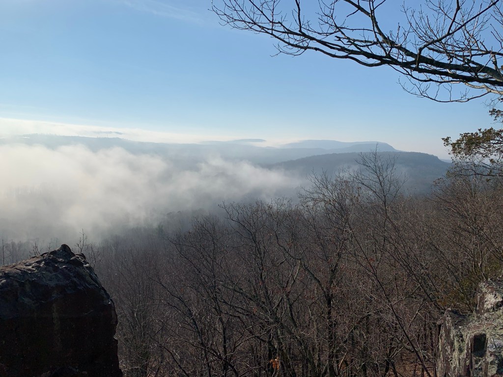
If you’ve ever done a long hike in the summer, then you’ve likely been relieved when a cloud provides you with some much needed shade. But, clouds also bring rain, premature darkness and sometimes severe weather. Cirrus-ly, clouds are an important part of our planets weather cycles and not writing an article about the different types and formations would be a mist opportunity (see what I did there?). I promise I am done with cloud puns…for now.
WATER VAPOR AND DUST
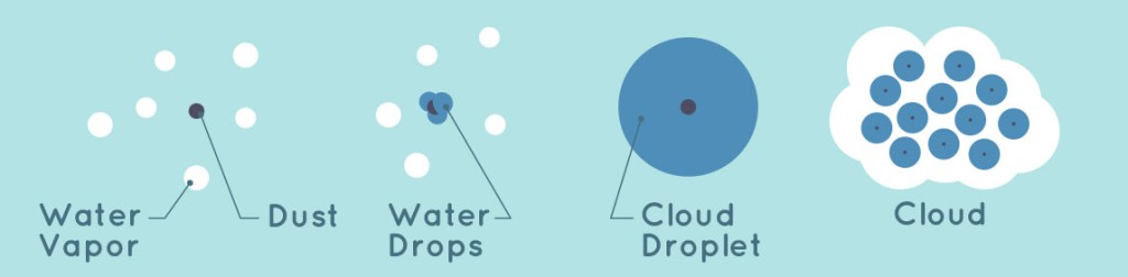
In order to have clouds in the sky, we need two things: water vapor and dust. Before we continue, it’s important that we discus the difference between water vapor and water molecules. Water molecules are always in a liquid form and closely packed together. Water molecules are what make up a glass of water. Water vapor is freely moving molecules that are uncontained. There is lots of space between them, and they are always moving. Water vapor is what appears above a boiling pot of water.
Now, lets get our head out of the clouds and get back to discussing clouds! Water vapor will not bond together under normal circumstances. The molecules are too far apart and moving too fast. To help them bond, they need a medium, which is dust.
The dust needed to make clouds is very complicated. First, it has to be very small. Particles can be no bigger than 1 micrometer (1 millionth of a meter) in diameter. Second, the dust has to be hygroscopic (meaning it attracts water). If the dust cannot attract water, then no bonding can occur. This dust can be smoke/ash from a volcano or forest fire, ocean spray, or wind-blown soil particles.
TEMPERATURE AND DEW POINT
Up until now, everything we have discussed has been in a gaseous state. However, clouds are mostly made up of water vapor and water droplets. In order to form a cloud, we have to convert the gaseous vapor into a liquid droplet. The process of converting a gas to a liquid is called condensation.
Just because we have dust and water vapor does not mean we have a cloud. We now need to discuss temperature and dew point. The Dew Point is the temperature at which the air can no longer “hold” the moisture present. The closer the temperature and dew point are, the more likely clouds will form. Warm air can “hold” more moisture than cooler air. As air cools, it can no longer support the moisture present (which has not changed), and the result is moisture condensing to form a cloud.
Instead of seeing this process in a large sky, break this process up into a block of sky, called a parcel. This parcel is where the dust and water vapor bonded together to make water drops. This bonding mostly occurs at the Earth’s surface where there is a big different between temperature and dew point. As warmer air rises, the lack of air pressure (air is thinner and molecules are more spread out at higher elevations) means molecules of dust and water vapor will spread out and cool. As the air cools, it approaches the dew point temperature. The water molecules can no longer be “held” by the air, and will condense onto the dust particle, forming a cloud droplet.

As more cloud droplets form, they begin to converge and form a cloud. However, our atmosphere is constantly changing and clouds are constantly forming. Evaporation and condensation are constantly occurring all over the sky. Clouds will grow when water vapor condensates onto more cloud droplets. If there is more condensation (air is moist and cooler) then clouds will grow. If there is more evaporation than condensation (the air is drier) then clouds will dissipate.
TYPES OF CLOUDS
Have you ever driven to work or school and had to navigate a thick layer of fog? If so, then you’ve been driving through clouds. The formation is exactly the same, and fog often builds close to the ground on the overnight hours because the temperature and dew point are close. Meaning, the cooler air cannot support the moisture, and the water vapor condensates. The reason fog “burns off” as the sun rises is because the temperature at the surface is warming. As the temperature and dew point become further apart, the moisture evaporates and the fog dissipates.
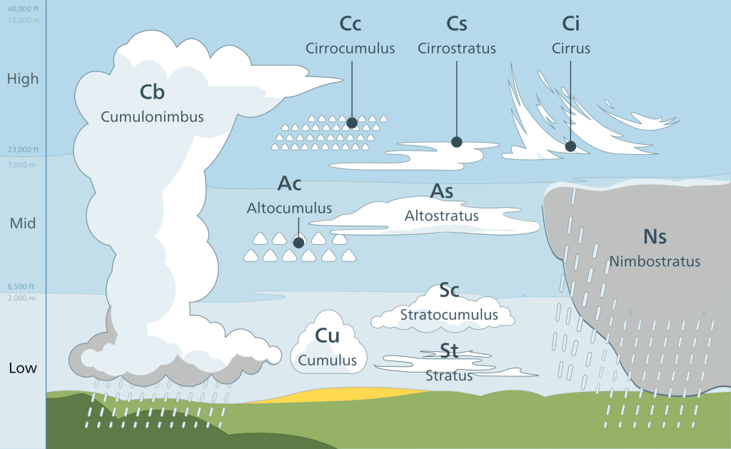
There are many different types of clouds, and most can be classified into 8 different types across 4 core categories. The core clouds categories are as follows: Cirro-form, Cumulo-form, Strato(us)-form, and Nimbo-form. Cirro-form clouds are rich in ice crystals and appear as wispy hair like formations. These clouds frequently appear in front of low pressure systems and storms. Strato(us)-form clouds are broad, flat and appear like a blanket in the sky. They often appear north of warm fronts.
STORM CLOUDS AND THE WEATHER
Derived from the Latin word nimbus, meaning rain, nimbostratus (nimbo-form) clouds come before storms and bring periods of steady rain and snow.
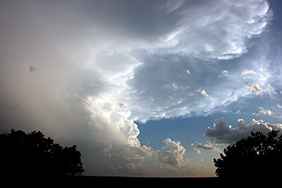
Cumulo-form clouds are fluffy cotton balls in the sky. These clouds change with the wind and sky and can form many different shapes and sizes. A type of cumulo cloud is responsible for tornados and thunderstorms.
High clouds-High clouds develop between 16,500ft and 45,000ft. Types include: Cirrus, Cirrostratus and Cirrocumulus. Cirrus and Cirrostratus clouds indicate a weather change within 24 hours is on the way. Cirrocumulus clouds develop in fair weather. However, these clouds often come before a tropical storm or low pressure front.

Mid clouds-Mid clouds develop between 6,500ft and 23,000ft. Types include: Altocumulus, Altostratus and Nimbostratus. Altocumulus clouds bring fair weather while Altostratus and Nimbostratus clouds bring rain.
Low clouds-Low clouds develops less than 6,500ft and include: Cumulus, Stratus, Cumulonimbus and Stratocumulus. Stratocumulus indicate good weather, but a storm is approaching. Cumulonimbus clouds indicate thunderstorms, hail and tornados are fast approaching. Cumulus clouds are fluffy cotton balls and are common on a good weather day. Stratus clouds bring fair but gloomy weather and are most associated with fog.
COLOR OF CLOUDS
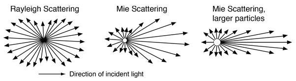
When we look at clouds in the sky, they often appear white against a blue sky. The sky appears blue because of Rayleigh Scattering (read more here). In short, Rayleigh Scattering is Earths atmosphere (gas molecules) filtering out all wavelengths of light except blue. This effect occurs in our atmosphere because the gas molecules scattering the light are smaller than the wavelengths passing through them. Clouds are composed of water droplets; these water droplets are similar in size to the wavelengths emitted by the sun. When the molecule size and wavelength size are similar, Mie scattering occurs.
Mie Scattering does not differentiate between wavelengths of light. All wavelengths of light are scattered the same and appear white (white being the presence of all wavelengths of light and color). Mie Scattering creates the white clouds during the day. During sunrise and sunset, Rayleigh Scattering creates yellow, red and orange colors while Mie Scattering scatters the remaining light within the cloud. Therefore, at dawn or dusk, the cloud will appear whatever color is created by Rayleigh Scattering.
Clouds can also appear gray or dark gray for two reasons. The first reason is under direct sunlight, a cloud can be semi-transparent. A blue background can be seen through clouds that are semi-transparent, giving them a dark gray appearance. A second reason is the thickness. Rain clouds are thicker, because of the moisture. These rain clouds become so thick they can block all sunlight passing through. The absence of light/scattering of light means the cloud appears dark gray.
CONCLUSION
Sadly, clouds can’t always be trusted, in-fact they are quite shady! There are many different types which can indicate many different things. And often times more than one type is present in the sky. All clouds form the same way, but if you know what exactly you’re looking at, then you can prepare for whatever nature has in store. So the next time you hike, be sure to get your head out of the clouds and instead look at them. They may tell you if its safe to continue hiking, or if you need to turn back and plan for another cloud free day!
REFERENCES
- https://www.weather.gov/source/zhu/ZHU_Training_Page/clouds/cloud_development/clouds.htm
- https://www.noaa.gov/jetstream/clouds/how-clouds-form
- https://climatekids.nasa.gov/cloud-formation/
- https://www.davisinstruments.com/pages/what-is-dew-point
- https://www.noaa.gov/jetstream/clouds/four-core-types-of-clouds
- https://www.scientificamerican.com/article/why-do-clouds-turn-gray-b/\
- https://scijinks.gov/clouds/
- https://www.noaa.gov/jetstream/clouds/color-of-clouds
